Two significant aviation events…
This month, May 2022, there have been two very different but significant aviation events. One aviation event that started out badly ended up with a good outcome, and the other aviation event that started out as a fun event quickly took a turn for the worse, with one fatality.
ATC controller steps up during aviation event!
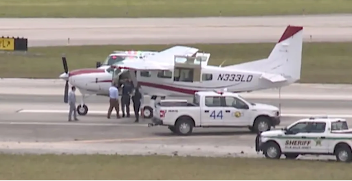
First, the good news. On Wednesday, May 11, a single engine turboprop, a Cessna 208 Caravan was successfully landed at Palm Beach Int’l Airport in Florida, KPBI, after the pilot became incapacitated. The Caravan was off-shore Florida, returning from a trip to the Bahamas, when the pilot suddenly became incapacitated. A passenger who was in the right seat, keyed the Push-To-Talk button on the yoke/control wheel, and told ATC, “I’ve got a serious situation here. My pilot has gone incoherent. I have no idea how to fly the airplane, but I am maintaining (at) 9,100 (feet),” the passenger told Fort Pierce air traffic control around 11:21 a.m.
When asked where he was, he replied that he had no idea. Controllers carefully explained to him how to turn and fly North, and then they were able to eventually determine his position on radar. The ATC controllers at the facility also realized that one of their controllers was also a flight instructor. They quickly found him and he immediately jumped into action, explaining to the passenger what to do, miraculously guiding the Cessna to a safe landing on the runway at Palm Beach International, at about 12:37pm. That was just incredible, to be able to land the airplane on the runway like that, for a non-pilot. Kudos to the pilot and instructor who is also an ATC controller! Well done!
High Surface Winds
Then on May 20, another aviation event started out with good intentions, but quickly took a turn for the worst. There was a gathering of pilots at the Wayne Muni./Stan Morris Field, KLCG, in Wayne, Nebraska, a small airport in the northeast Nebraska. Pilots were there for a friendly STOL (short takeoff and landing) competition. It was planned to be a four-day event, complete with sponsors.
However, the weather did not cooperate, as there were high surface winds, and some  contests were improvised as a result. During the fourth heat of one contest, one pilots’ Cessna 140 got low and slow while maneuvering on final approach following another airplane and suddenly rolled inverted (stall/spin?) at about 300’, leaving no room to recover. It was suddenly pointed straight down, quickly striking the ground and killing the pilot on impact! OMG!
This was a quite a shock to all who were there. Immediately after this, the STOL event was canceled, and the participants responded appropriately, offering what support and condolences they could to the family of the deceased. They then departed. My condolences, thoughts, and prayers as well, to the family of the deceased pilot, Tom Dafoe. He owned the Cessna 140 he was flying. An investigation into this accident will be taking place.
What a contrast. Sometimes things go this way. Aviation can be terribly unforgiving at times, even to experienced pilots. It happens. There are always lessons to be learned.
What about you? How’s your flying? If you’d like to review anything, any maneuvers, or review any subject matter, please let me know. We can arrange a time and place or do it virtually via Zoom. I’m flexible.
Fly safely,
John
Flabob Airport, a step back in time
Fun Flying my 92-year-old pilot friend to Flabob Airport, a step back in time
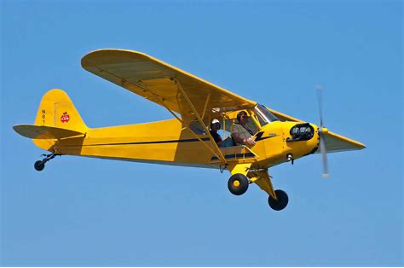
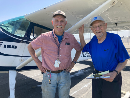 In early April, I had the opportunity to give an airplane ride to a pilot friend of mine to Flabob Airport, who is now 92! What a treat! At 92, he is still sharp as a tack but is hard of hearing. Of course. But he was able to get up and around. Gene career was in engineering. He has been both a pilot and aircraft owner for many years, but no longer flies. But I recently learned that he would very much like to go up again, and ‘slip the surly bonds’, as the poem goes, so we did. A friend and I took care of the arrangements.
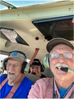 We met at the airport, and took pictures before getting in. Then I helped him to climb into the front right seat, which is a BIG step up in a Cessna 180. Then I carefully closed his door and got in on my side. We took off from Long Beach Airport and went on a short, 25-minute flight, at about 2,500’ east over the LA basin, to Flabob Airport in Riverside, CA. To my surprise, Gene had not flown into Flabob before. Flabob Airport is like a step back in time. A single runway, non-tower airport, home to many Vintage aircraft, including the DC-3 that I was able to fly in September 2021.
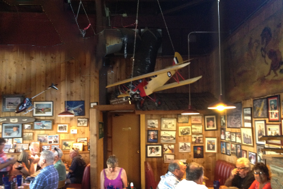
We taxied in and parked in front of the Flabob Airport Café, then went in and had lunch. The Flabob Café is a family run restaurant, decorated with airplane memorabilia from a bygone era. Both the food and service are good. Following lunch, we made our way back to the airplane and took off again for Long Beach. Gene thoroughly enjoyed the flight! It was my pleasure to be able to take him on a flight. Once a pilot, always a pilot! It was also fun to fly my Cessna 180 again, because I don’t fly it as much as I used to.
How about you? What kind of fun flying have you done, lately? I hope you are doing some FUN flying, to FUN places!
IF you’d like to review anything, maneuvers, or book work, please let me know. We can arrange a time and place, or do it virtually via Zoom. I’m flexible.
Fly safely,
John
Aircraft mechanics – we need ‘em!
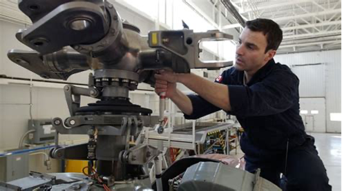
The March/April 2022 issue of the FAA’s Safety Briefing magazine is ALL about ‘Meet the Maintainers’, referring of course to what we informally refer to as ‘A&Ps’, aka Airframe and Powerplant Mechanics. Or more formally known as an AMT, aviation maintenance technician. Regardless, we need ‘em to maintain our airplanes. Aircraft mechanics ARE vital to our having aircraft that are safe and airworthy to fly.
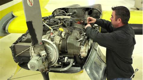 IF an airplane is not properly maintained, various components are prone to suffer from neglect and exposure to the elements, like the sun and moisture, heating, and cooling. Corrosion forms. Tires go flat. Hoses grow old and brittle and begin to crack. Once tight fittings become lose. You get the idea. No doubt, some are flown anyway, by pilots who have their own ideas about this kind of thing. We tend to read about those who do this stuff.
Way too many pilots do not know nearly enough about the airplanes they fly, and what’s required to keep ‘em flying. Seriously. I was one of them, myself, many years, no, make that decades ago when I was just starting out, learning to fly. I’ve learned quite a bit now being an airplane owner myself, but there is always more to learn.
I come from a (family) background that was not necessarily mechanically oriented. What did I know? Not nearly enough, looking back. And now, because of our ‘throw away’ modern culture, where many things are not repaired but instead are replaced, not many bothers to learn about machines of any kind, nor what it takes to keep them running anymore.
 So, this month the FAA recognizes and celebrates the ‘maintainers’ as they refer to them. It’s no small responsibility. And, you may be surprised to know, AMT’s have their own FAA requirements that they have to meet, which of course includes ongoing education, just like pilots. They also have an award, like pilots, recognizing those who have 50 years’ experience as AMT’s, which is the Charles Taylor Master Mechanic Award.
Way back when, Charles Taylor was the mechanic whom the Wright Brothers hired to fix bicycles in their bicycle repair shop, in Dayton, OH, but he ended up also designing and building the 4-cylinder engine used in their historic Wright Flyer, their first powered airplane, with which they made their historic flight back in December 1903.
So, my hat is off to all of those who keep us flying, in our many different aircraft. Our flying machines; many different shapes and sizes for a wide variety of ‘missions’. Thank you for ALL that you do to keep us flying. And my Cessna 150 is scheduled for its ‘annual’ inspection next month, April. I will be helping out my mechanic, without getting in the way, as he systematically goes through inspecting all that needs inspecting. So, I learn more about my airplane in the process. It’s all part of ownership, as I see it.
And, if you want to work on improving your flying knowledge, skills, and proficiency, get in touch with me. Let’s schedule some time to work on whatever is needed.
Fly safely,
John
Flying the Stearman Biplane
 I recently had the opportunity to fly a Stearman biplane again! Flying the Stearman is fun!
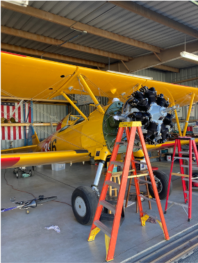
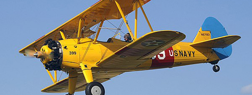
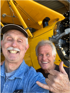
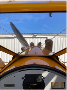
My friend Mike Hanson owns a beautifully restored 1943 Stearman biplane, based at nearby Compton, Airport, KCPM, in Compton, CA. We had a deal; he flew with me in my 1970 Cessna 150 for some required proficiency training to maintain his pilot qualifications, and in return he offered me a chance get a ride in his Stearman and fly it!
Well, flying the Stearman is SO MUCH fun!! I last flew a Stearman about 35 years ago, at a small airport in Harvard, Illinois, northwest of Chicago. It was a beautiful day here in Southern California. And, despite the Stearman’s larger size, and because of the drag of the large struts and the large frontal area of the Continental R-670-5 radial engine, it is really not that fast, either. But flying ‘open cockpit’ is fun!
To my surprise, it is light on the controls, and is easy to fly! But the view from the cockpit for maneuvering on the ground and for takeoff and landings is a 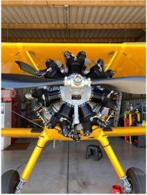 challenge. Because we sit behind the engine, we can only look to either side. I sat in front, and Mike was in the rear, on the controls. We wore leather flying jackets and headsets and had an intercom so we could communicate. I was a passenger as he taxied out and did the takeoff and the landing. Once in flight, he let me fly. What fun!
Our route of flight was “straight-outta-Compton” 1000′ agl, Alondra Park, then southwest to King Harbor then wing-up southbound along the shoreline to Palos Verdes Peninsula, L.A. / Long Beach Harbors, Queen Mary, North 710 LGB transition for the overhead approach returning to Compton.
Along the way, over the Breakwater at the edge of the LA harbor, we did some ‘turns about a point’, or ‘ground reference maneuvers’, as they are called, when you maneuver down low, between 600’ and 1,000’, and try to maintain a prescribed course over the ground while correcting for the wind. That’s how student pilots learn to correct for the wind. And, when we were up higher, at about 3,000’, I did a few medium and steep banked turns (60°), and then a power off (at idle) stall or two. It was fun to practice this basic maneuvers. It was fun flying around in a big yellow biplane on a sunny afternoon! IF you are interested in getting a ride in this Stearman, their website is www.biplanefun.com
 Flying the Stearman is wonderful for practicing basic ‘stick ‘n rudder’ skills! Remember, the Stearman was used for primary pilot training by the US Army Air Corp (before it became the US Air Force) back in early WWII and taught 1000’s of army pilots basic flying skills. Hence the designation, PT-17, Primary Trainer.
Have you, the reader, if you are a pilot, practiced basic stick ‘n rudder skills lately? If not, get in touch with me and we can do this in the airplane you are flying. It’s so important to keep your basic flying skills sharp! Too many pilots are letting their piloting skills atrophy with more and more automation in the cockpit, as I mentioned in a recent blog.
Fly safely,
John
More stick time for pilots?
It is being reported in the Feb. 7 edition of AvWeb, that the FAA is concerned about a lack of ‘stick time’ for pilots. According to the pending Advisory Circular (AC) 120-FPM, which is in ‘draft form’, with the subject being ‘Flightpath Management’(FPM), this AC addresses “manual flight operations, termed ‘MFO’, including managing automated systems, pilot monitoring (PM), and energy management.’ That’s mouthful.
More ‘stick time’ is needed by pilots
What it amounts to is nothing new. We’ve been saying this for decades. With the increased reliance on automated systems in the cockpit, the FAA is now concerned that pilots ‘stick ‘n rudder skills’ are deteriorating, and more ‘stick time’ is needed by pilots, to maintain proficiency.
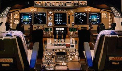
 A question: if this is being proposed by the FAA for airline and charter pilots, then what does this say about GA pilots, some of whom fly very sophisticated, very capable airplanes with lots of automation. Many are more sophisticated than some Boeing or Airbus aircraft. Heck, even single engine turboprop aircraft like the TBM 900 series boast very high-end avionics.
So, some questions for you, the reader. What’s your take on this? Are modern cockpits becoming too automated? If you the reader are a pilot, how automated is the cockpit of the airplane you fly? Do you have an autopilot? If so, how often do you use your autopilot?
Post your comments below.
Crosswind Landings
Challenging Crosswind Conditions
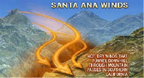
 We recently had ‘Santa Ana’ conditions here in SoCal. What causes this? Typically, it’s due to a high-pressure system over Utah or Nevada, with its clockwise flow, which funnels hot dry air southwesterly through the mountains surrounding the LA basin. When that happens, there is a strong northeasterly flow in parts of the basin, which means strong, gusty north-northeasterly surface winds at some airports. This creates very challenging crosswind conditions for takeoffs and landings. How proficient are you with this?
Many pilots struggle with crosswind landings. This is because they don’t fly enough on windy days. They are simply out of practice. How about you? Do you ever fly on days like this? I can help. Get in touch with me.

5-7-9 Rule
Are you familiar the 5-7-9 rule of thumb, for crosswinds? It’s easy to use. See the diagram to the left. If the winds are 30° to the runway at 10 knots, the crosswind is 50% of the wind value. So, for runway 36 shown here, if the wind is 030 at 10, there is a 5-knot crosswind. 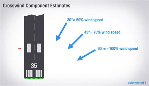 If the wind is 45° to the runway, or 040 or 050 at 10, the crosswind is 70% or about 7 knots. If the wind is 60° to the runway, or 060 at 10, the crosswind 90% of that, or about 9 knots. This is all based on (Algebra) and Trigonometry but is simplified for our purposes. What’s the demonstrated crosswind for the airplane you fly?
How comfortable are you with crosswind takeoffs and landings?
If you would like to get some practice with crosswinds, please get in touch with me and I’ll work with you to improve your crosswind skills.